THE LYNN SUTTON BRIDGE RAILWAY

We recommend viewing this page on a desktop pc, laptop, or tablet for a better viewing experience.
Railway mania was beginning in Norfolk. The Lynn Ely Railway opened in 1846, and the Lynn Dereham Railway also commenced operations at the same time. In August 1861, the Lynn Sutton Bridge Railway was authorised by Parliament and opened in 1864, along with lines from Wisbech and Bourne that all connected at Sutton Bridge. Historical maps show this railway initially as the Bourne and Lynn Railway.
The Lynn Sutton Bridge Railway initially operated services from the original wooden station in King’s Lynn. This was later replaced by a brick station built by Robert Skipper of Dereham in 1871, which still stands today.
The government wanted the Lynn Sutton Bridge Company to construct a new rail and road bridge at Sutton Bridge. However, the Lynn and Sutton Bridge Railway Act of 1863 modified this, permitting the railway to purchase the existing crossing, which had been built in 1850.
Departing from King's Lynn, the Sutton Bridge railway line initially used the Lynn Ely line before heading to the southern edge of the town at Harbour Junction. From there, the line diverged towards Sutton Bridge, with the next station being West Lynn. However, the single-platform station at West Lynn was short-lived, and little historical detail is available about this old station. I found that it was estimated to have been open from 1866 to 1886.
After West Lynn, the line called at Clenchwarton, Terrington, and Walpole before reaching Sutton Bridge.
In 1886, the Lynn avoiding line opened, with South Lynn station, diverting traffic away from King's Lynn's heavily congested main station. The line to Sutton Bridge now ran from South Lynn station.
The Cross Keys bridge: The first bridge opened in 1831, and a replacement bridge was opened in 1850. The second bridge was a swing bridge, similar to the one seen today. From 1850 onwards, the bridge was used exclusively for road traffic until 1864, when the railway also gained the right to use it.
The present bridge, which still stands today, was constructed in 1897 for £80,000.
This was the third bridge constructed.
To put this in perspective, the whole of the Hunstanton line, when constructed, cost £80.000.
The newly built bridge altered the track alignment at the approach to the Sutton Bridge from the east to accommodate the newly constructed bridge. It was originally hoped that the 1850 bridge could be kept for rail use, but it was considered a hazard, so it was demolished.
In the late 1890s, the Midland and Great Northern Joint Railway was formed
(Nicknamed the Muddle & go Nowhere)
The M&GN took control of the Lynn Sutton Bridge line, as well as the Peterborough, Wisbech, and Bourne lines to the West, the Lynn Fakenham line, the Norwich city, Cromer, and Great Yarmouth lines, and the Melton Constable works and junction to the East.
In 1958, a report by British Railways concluded that the M&GNJR was making no money and was redundant, as Wisbech, Peterborough, Norwich, and King's Lynn all had other stations in their towns supported by different railway companies. In early 1959, most of the M&GN was closed, with some small sections remaining open for freight use. The only parts of the M&GN still in use are Cromer station, formerly Cromer Beach station, and West Runton station, with Sheringham and Weybourne still in use as part of the North Norfolk Railway.
Part of the closure was rumoured to be that the bridge that crossed the River Ouse at South Lynn was beyond repair, and constructing a new railway bridge would have cost more than the railway was making.
King’s Lynn Town station
The original station in King’s Lynn, from which the Sutton Bridge railway first started, is still used daily for services to London King’s Cross.
South Lynn.
Opened on 1st January 1886 and closed to passengers on 2nd March 1959. It remained open as a coal depot until 1966.
Sutton Bridge.
It opened on March 1, 1866, and closed to passengers on March 2, 1959; Sutton Bridge closed to freight on April 5, 1965.
All intermediate stations along the route were also closed in 1959.
When I wrote this page, all that remained of the Lynn Sutton bridge railway was a bridge and some small parts of the railway track close to Harbour Junction near South Lynn. I'm unsure if the bridge was original or replaced over time. All stations along the route have been demolished, with only a small memorial at Walpole dedicated to the long-lost railway. The track bed was repurposed into the A17 bypass, which, in many parts, follows the old track bed. At Sutton Bridge, the Swing bridge, known as Cross Keys Bridge, still exists and is in daily use, carrying A17 road traffic over the River Nene.
The river Nene leads into Wisbech Docks and serves Sutton Bridge Docks from the Wash.
King’s Lynn (Town) Station
Before the Lynn avoiding line was built, the Lynn to Sutton bridge line left from what was then known as King’s Lynn Town station. The station was originally constructed in 1846 as a wooden structure and was rebuilt in 1871 as the brick station we see today.
King’s Lynn station now has three platforms and once had services not only to Sutton Bridge but also to Fakenham. The Lynn Sutton Bridge railway and the Lynn Fakenham line were later connected at South Lynn via the Lynn Avoiding line. Lynn also once had services to Dereham, Hunstanton, March, and London, with the London services continuing to this day.

©The National Library of Scotland
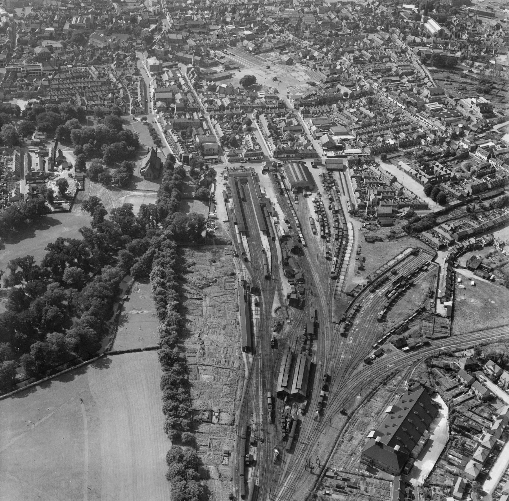
The railway station and environs, King's Lynn, 1950 © Historic England. Aerofilms Collection EAW031881 flown 14 August 1950

©Year and photographer unknown

©Year and photographer unknown
King’s Lynn station in 2020


Leaving King’s Lynn, the railway headed off towards Sutton Bridge along the Lynn Ely line as far as Harbour Junction on the Southern edge of the Town.

©The National Library of Scotland
The track lay out after the Lynn avoiding line was built.

©The National Library of Scotland
Lynn Sutton Bridge railway Track bed & Bridge.
Leaving the Lynn Ely line at Harbour junction, the railway headed west towards Sutton Bridge.
Once the Lynn avoiding line was constructed, this small section of the track was retained to take services from South Lynn to King’s Lynn town station.
It is unclear when this line ceased operation. Nonetheless, it remained in use long after the M&GN closed, primarily for freight transport.
Drone footage of where the Harbour junction once ran.

The disused track bed that once took the Lynn Sutton Bridge railway off from the Lynn Ely line at Harbour Junction


The date stamp indicates that the track and fittings have been unsurprisingly replaced since the Lynn Sutton Bridge line.


The River Nar crossing bridge
Initially, the Lynn Sutton Bridge line would cross the River Nar using this bridge or possibly an earlier one. This bridge was then used to connect the Lynn Ely line to the M&GN after the Lynn-avoiding line was built. It was located just beyond the remaining track, as shown above. There is limited information available, and it is unclear whether this was the original bridge constructed for the Lynn Sutton Bridge line.
50/50 map coverage of the Lynn Sutton Bridge railway, and also the second picture showing the line after construction of the Lynn avoiding line.

©National Library of Scotland

©The National Library of Scotland
The Lynn Sutton Bridge line would initially have crossed the River Nar using this bridge.


Shortly after this bridge, the line would initially reach West Lynn station and, later on, South Lynn.
South Lynn Station
South Lynn Station was not part of the original Lynn Sutton bridge line and was constructed later in 1886 as part of the Lynn avoiding line.
South Lynn station was built after King’s Lynn town station, which was constructed in 1846. The next station along the Lynn Sutton Bridge railway was West Lynn, located on the western side of the River Ouse. West Lynn station was closed in 1866, and with the construction of the Lynn avoiding line, South Lynn station opened in the same year.
In its later years, South Lynn served the M&GN and had numerous freight sidings constructed over time to supply various industrial companies in the vicinity. South Lynn had two passenger platforms and was closed in 1959.
To this day, nothing remains of South Lynn station. Most of the land the station stood on remains wasteland, with a small portion occupied by the A47 dual carriageway.
Historic maps below show the area where South Lynn railway station would be constructed in 1886

©National Library of Scotland.
Historic Maps of South Lynn Station.

©National Library of Scotland.

©National Library of Scotland.
Historic Photographs from South Lynn

©Photographer and year unknown

Ben Brooksbank / Ex-GE B12/3 4-6-0 on Rail Tour at South Lynn / CC BY-SA 2.0

Photographer and year unknown
South Lynn site in 2025

Off to Sutton Bridge
River Ouse crossing
The railway crossed the River Ouse just south of South Lynn via a bridge located roughly where the current A47 crossing bridge now is. The A47 bridge was built some time after the railway bridge was demolished, and I found no trace of the old railway bridge during my visit. This old railway bridge was said to have contributed to the closure of the M&GN, as the cost of replacing the deteriorating bridge was deemed too high, and losing this river crossing severed the link between the M&GN from Lincolnshire to Norfolk, starting the process of shutting down the M&GN network.

The Free Bridge, Railway Bridge and South Lynn Station, King's Lynn, from the north-west, 1932 © Historic England. Aerofilms Collection EPW039193 flown July 1932
Please click on the aerial image for the Source page.
©National Library of Scotland
Historical map showing the railway as it was dismantled.
©National Library of Scotland
The 50-50 map coverage below shows where the A47 dual carriageway now occupies the route of where the railway once ran.

©National Library of Scotland
Leaving King’s Lynn between 1864 and 1886, and South Lynn between 1886 and 1959, the railway headed off to Sutton Bridge. The railway called at West Lynn pre-Lyn Loop days, 1866 to 1886, then after the railway called at
Clenchwarton
Terrington
Walpole
Sutton Bridge
The railway closely followed the path of the current A17 bypass, and no stations still exist. The only remaining remnants of the railway are a memorial at Walpole and Cross Keys Bridge (also known as Sutton Bridge).
West Lynn Station
West Lynn station was operational during the early days of the Lynn Sutton Bridge railway. It was the next station after the main station in King’s Lynn. West Lynn station was a simple, one-platform station, and the history of this long-lost station is quite limited.
Once the Lynn avoiding line and South Lynn were constructed. West Lynn station was closed.
1866 1866

©National Library of Scotland
60/40 map coverage of where West Lynn station once stood.

©National Library of Scotland
Clenchwarton station
Clenchwarton station was once a two-platform station on the Lynn Sutton Bridge line in Norfolk. The station opened in March 1866 and closed in March 1959.
Nothing remains of this station today in any form.

©National Library of Scotland

©National Library of Scotland

Year and Photographer unknown
Terrington station
Terrington station was once a two-platform station on the Lynn Sutton Bridge line in Norfolk. The station opened in March 1866 and closed in March 1959.
Nothing remains of this station today in any form.

©National Library of Scotland

©National Library of Scotland

©KL forums Littleoldboy

©KL forums Littleoldboy
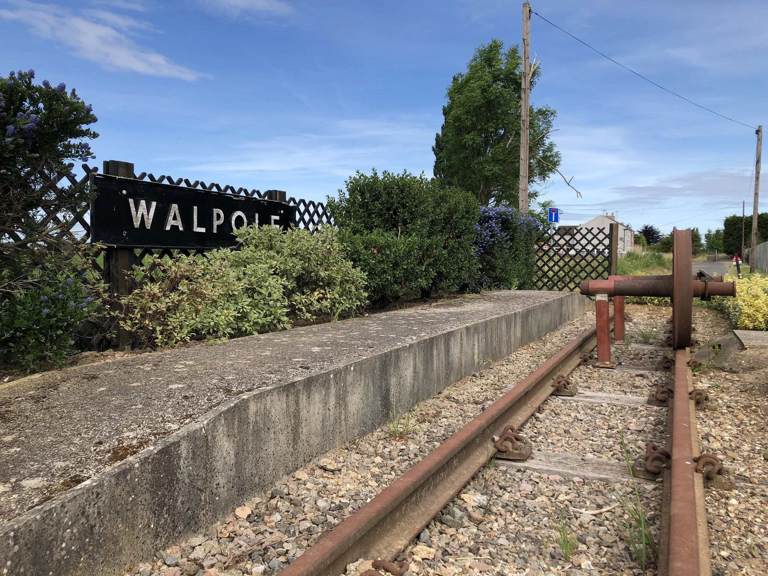
Walpole station
Walpole station was once a two-platform station on the Lynn Sutton Bridge line in Norfolk. The station opened in March 1866 and closed in March 1959.
Walpole station was the nearest station to the Lincolnshire border and took its name from the nearby villages, notably Walpole St Andrew and Walpole St Peter, as well as Walpole Highway and Walpole Cross Keys, with the latter being the closest village.
Nothing remains of this station today in any form.
A railway memorial has been installed close to the site of the old station.

©National Library of Scotland

Walpole Memorial

Leaving Norfolk and off to linconshire
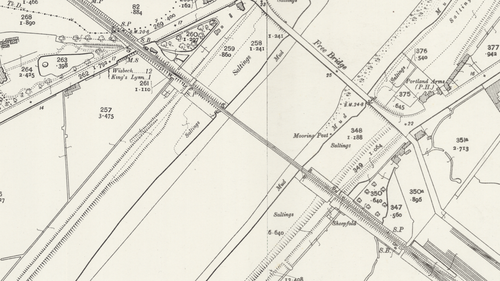
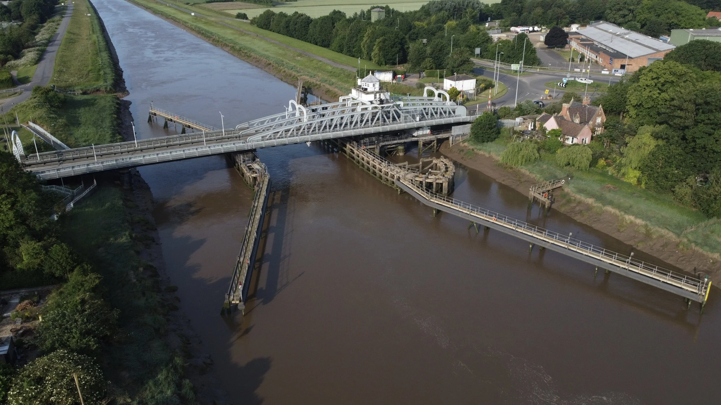
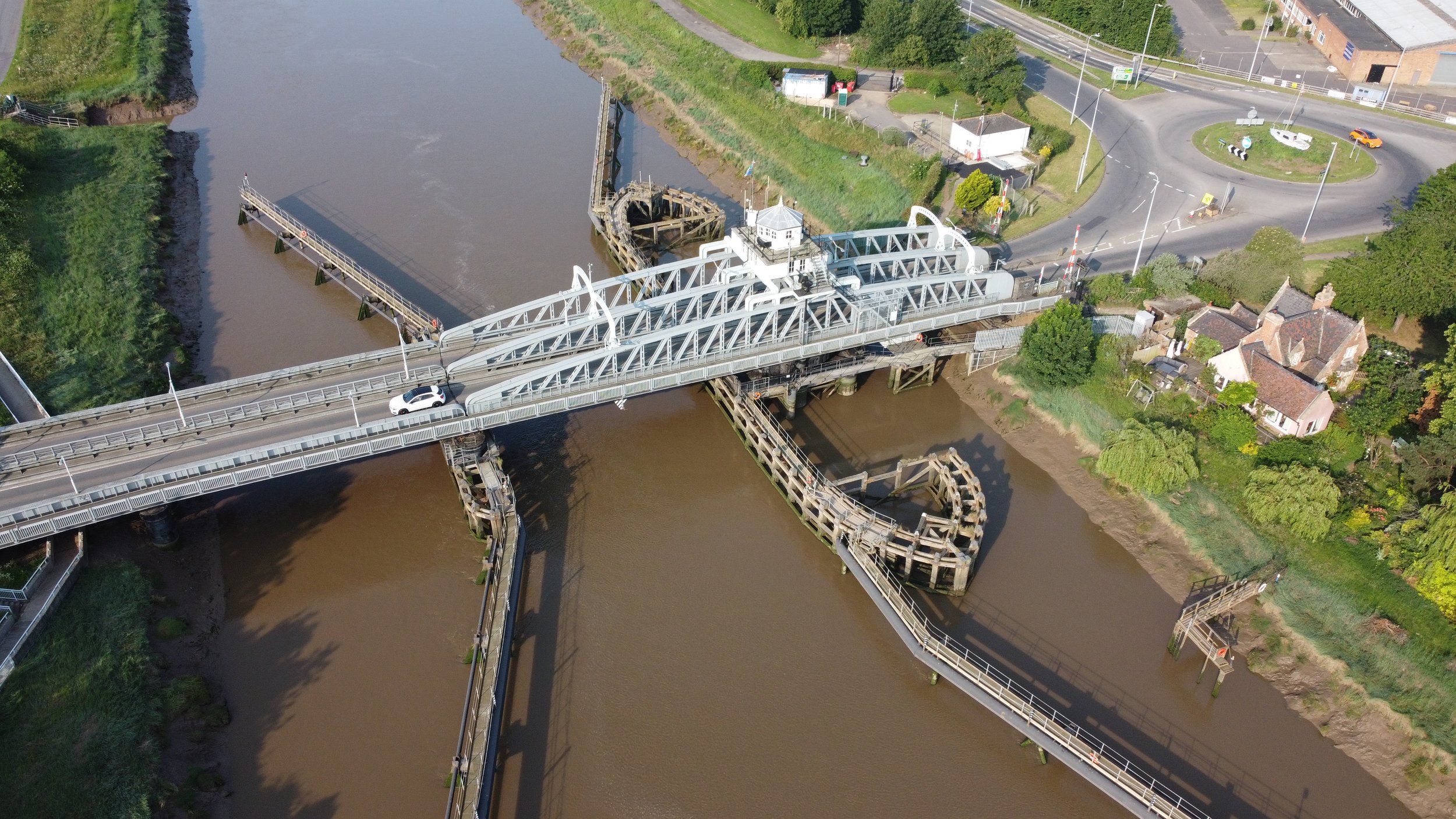
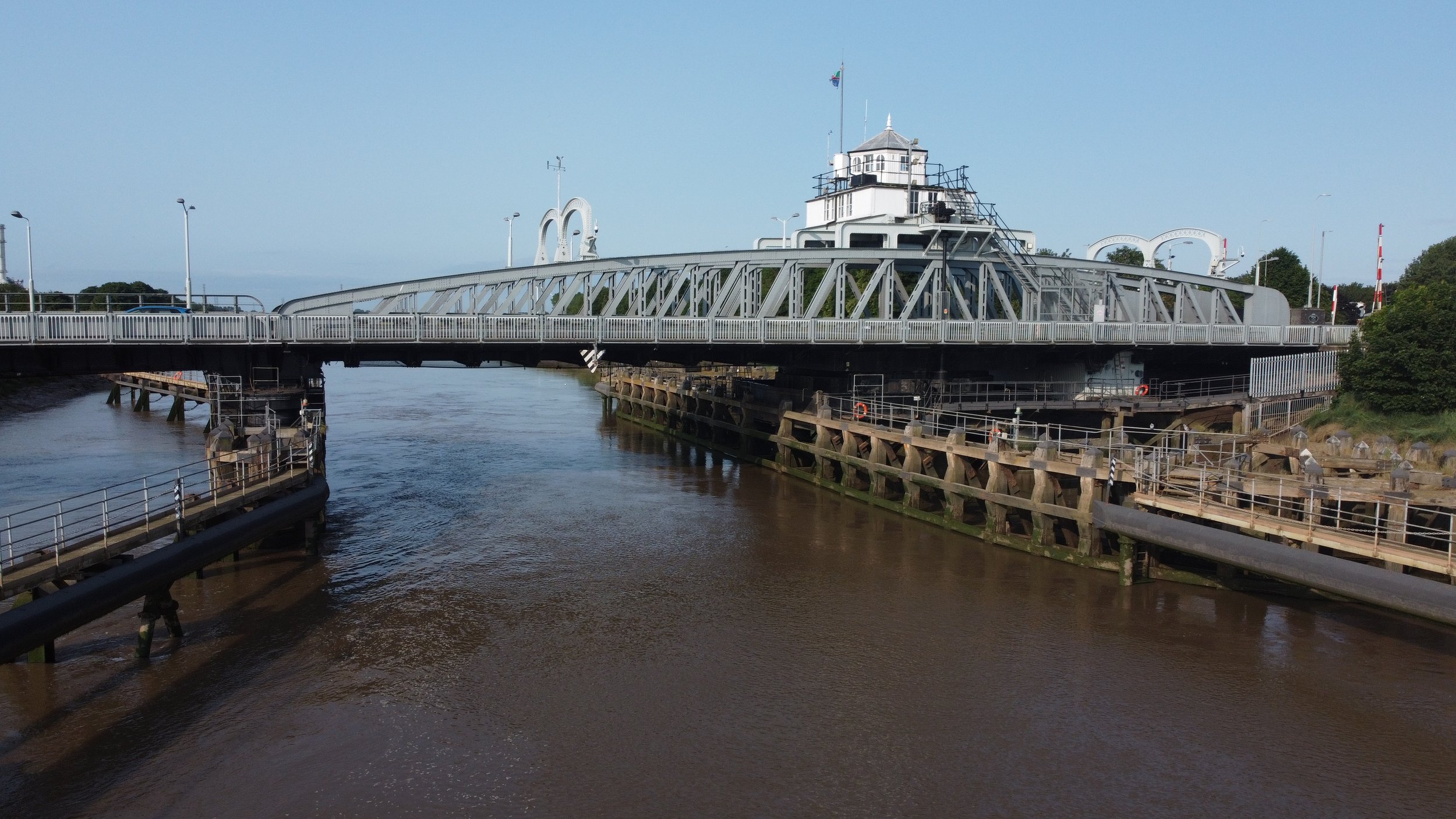
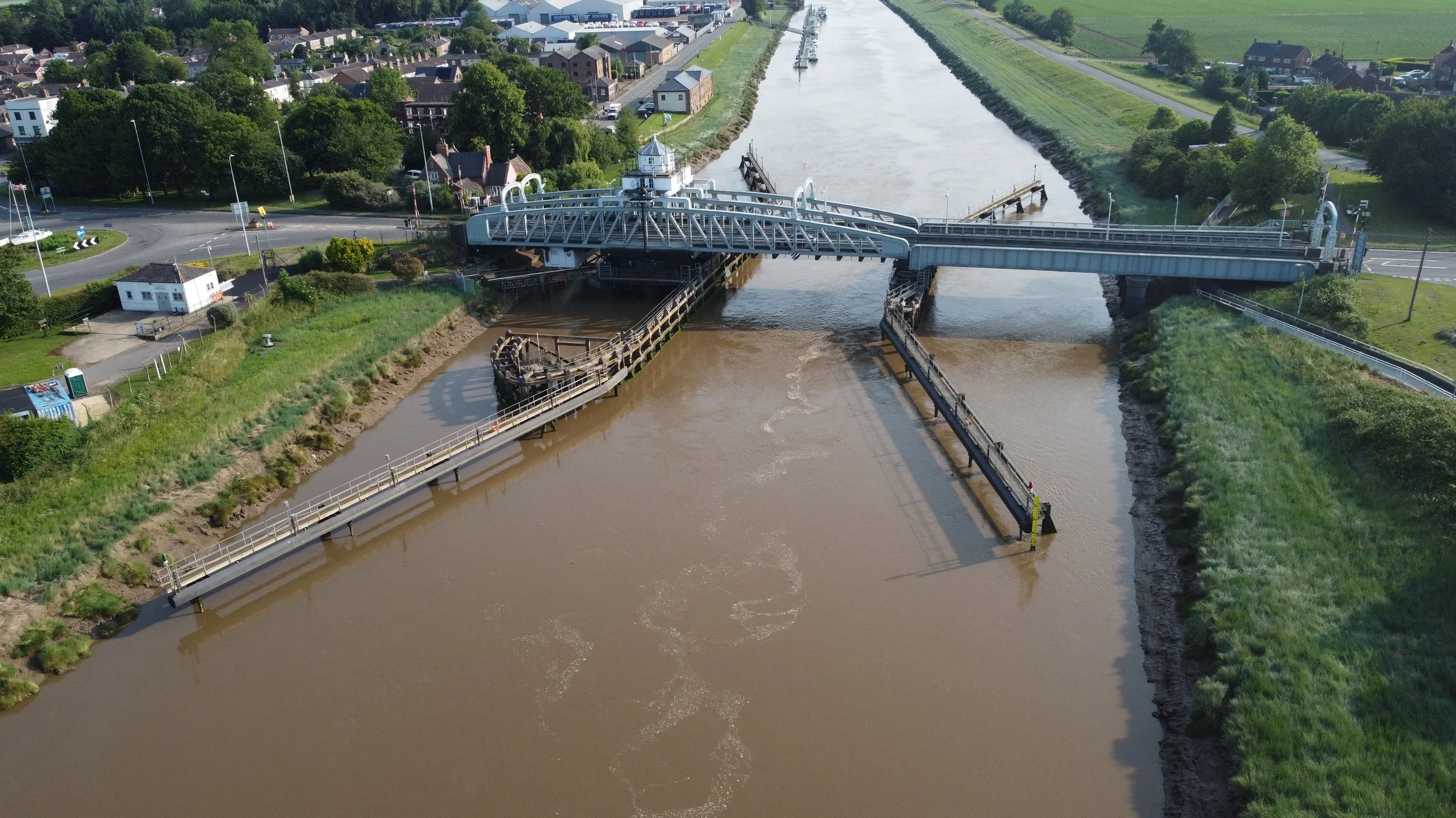
Cross Keys Bridge
The Cross Keys bridge that we see today was the third bridge built to cross the river Nene at Sutton Bridge. The first bridge opened in 1831, and the replacement bridge opened in 1850. The second bridge was a swing bridge, similar to the one we see today. From 1850, the bridge was used for road traffic only, until 1864 when the railway also acquired rights to use it.
The present bridge, which still stands today, was constructed in 1897 for £80,000. It was initially hoped that the 1850 bridge could be kept for rail use, but it was considered a hazard, so it was demolished.
The westbound carriageway was for railway use, while the eastbound lane was used for road traffic until 1965, when the railway closed to freight use. The bridge was then converted to the road crossing we see today, carrying A17 traffic over the River Nene.
Thanks to the National Library of Scotland, the historic maps below display the layout of the Cross Keys Bridge during the railway era.

©National Library of Scotland
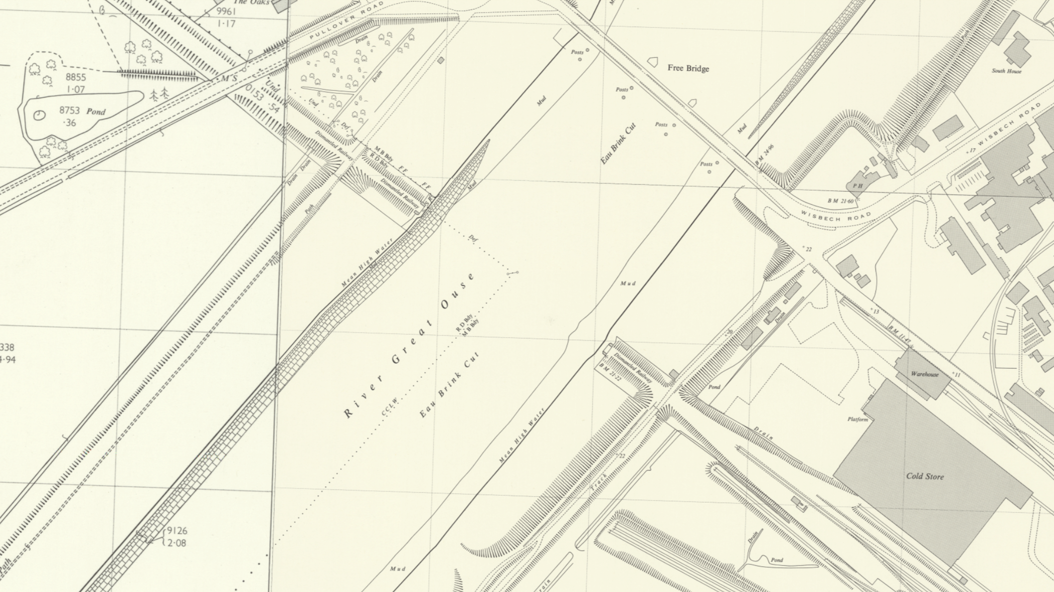
Historic maps below show the railway has been removed, and the A17 at this point has not been redirected to run along the old track bed alignment. Also, the A17 runs through Sutton Bridge centre through Bridge Road.

©National Library of Scotland
The Sutton Bridge maps have a split view displaying historic maps and modern-day maps. They show that the A17 used to follow a different route, whereas now it runs along the old track bed of the Lynn Sutton Bridge railway. On the opposite side, where the railway was formerly located, there is now an industrial unit. The access road to Bridge Road has also been altered because of the removal of the old railway.

Modern Google Maps
Historic aerial photography

Cross Keys Swing Bridge, Sutton Bridge, 1932. This image has been produced from a copy-negative. © Historic England. Aerofilms Collection EPW039205 flown July 1932
Please click on the photo for the Source page

Bridge Road and environs, Sutton Bridge, from the south-east, 1932 © Historic England. Aerofilms Collection EPW039204 flown July 1932
Please click on the photo for the Source page
Historic photos.


©facebook Lincolnshire railways

Modern Photos.
Photographed in 2021


Underneath the bridge.


Construction plaque.

Cross Keys | Sutton Bridge Aerial pictures.
2025
View of the approach to the Swing Bridge in June 2025, taken above the A17 early in the morning with no traffic. When the railway was operational, the line curved slightly before crossing the River Nene using the Cross Keys Bridge, making the A17 layout here somewhat different from what the railway used.

Cross Keys Bridge. photographed in 2025

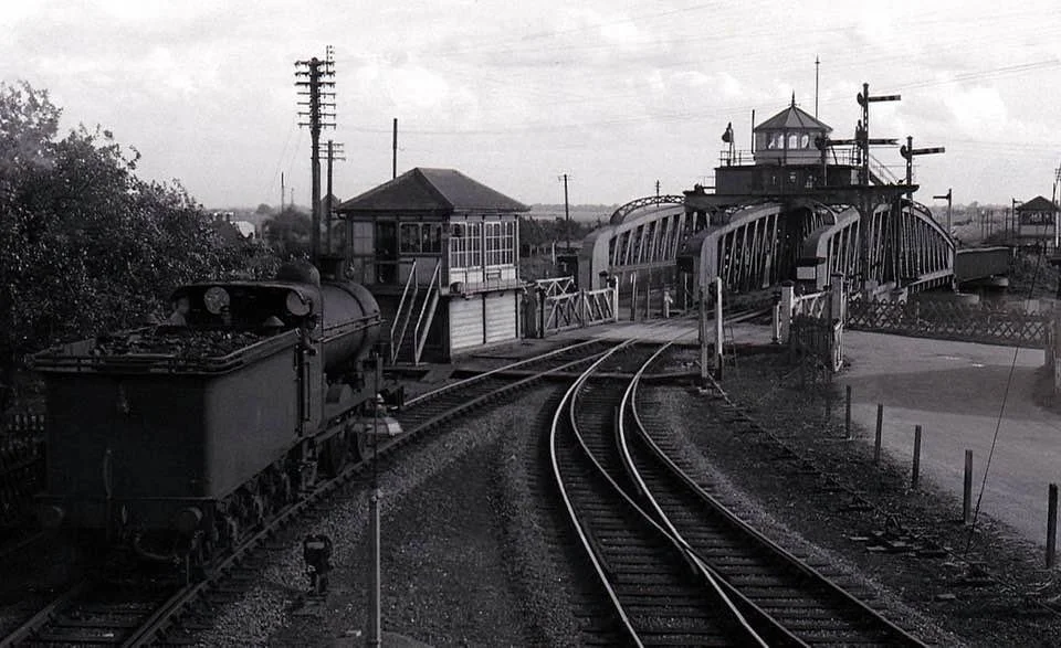
Sutton Bridge station
Sutton Bridge station in South Lincolnshire opened in 1866 and later became part of the Midland and Great Northern Joint Railway. Sutton Bridge had two platforms that served Great Yarmouth, King’s Lynn, Melton Constable, Wisbech, Peterborough and Spalding. and also a dead-end platform that would have served only Wisbech, Peterborough, and Spalding.
The station closed to passengers in 1959 and to freight in 1965. Today, there is no trace of the lost station to be found whatsoever.

©National Library of Scotland
Sutton Bridge after closure

©National Library of Scotland
Modern Google Maps coverage of the old station site
Please click the square icon on the map for the satellite image.
Historic Photos of Sutton Bridge Station

year and photographer unknown

year and photographer unknown

year and photographer unknown
Heritage South Holland Sutton Bridge website
My Google Maps
The Lynn Sutton Bridge railway Google map coverage.
My Google maps coverage of all the M&GN stations.
Thanks for looking.
More pages that may be of interest.