SWAFFHAM TO FRANSHAM
1846-1968

To navigate through the route, kindly make use of the navigational icons located below that correspond to each part of the route.
SWAFFHAM STATION
Swaffham station is situated some 14 miles 37 chains from King’s Lynn.
On August 10th, 1847, Swaffham station was opened with two platforms in a town that has said in the 1950s to have a population of 3000. The primary station buildings were located on the upside, with access to the downside facilitated by a footbridge. The station was constructed in a "Tudor" style, featuring decorative windows and Dutch-style gable ends.
On September 20, 1875, Swaffham station became a junction with goods services operating on the line from Watton and Thetford. Passenger traffic started a few months later, on November 25. However, on June 15, 1964, the line was shut down for passenger use.
Entry to the station was through a recessed door situated in the middle of the main building, with two decorative windows on both sides. The front of the station was made flush to support the canopy.
The main platform featured a large canopy, while the down platform only had a waiting shelter.
Swaffham station features double tracks passing through the platforms, accompanied by extra loops on both sides of the running lines. On the downside, the primary goods yard has three sidings, with one of them serving a large goods shed. The other two sidings are dead-end sidings, while additional storage sidings are located towards the east.
Swaffham also boasted private sidings for companies such as “Vynne & Everett”
Swaffham also boasted a 45-foot locomotive turntable with a locomotive shed that was only accessible from the turn table, this shed was situated on an elevated position causing a locomotive to tumble over the edge of the bank and the need to winch back up.
(There is a close up historic map of the turntable and shed below)
The shed housing the locomotive was constructed using cheap timber and did not survive the diesel era, leading to its closure in the 1960s.
The station was controlled by two signal boxes one being on the upside near the footbridge and the other site to the east near Swaffham junction.
Usage and services at Swaffham, like other stations along the line, slowed down. The Thetford branch closed on June 15th, 1964, and the station stopped serving passengers on September 9th, 1968.
Swaffham in the present day is hidden away and now used as what I could make out a social services centre, and on a Sunday when I visited, a few HGVs were parked up for the weekend in the old station area. One of the platforms is still intact. The station house has been converted into a private residence. The brick goods shed has also been preserved and is currently used as an industrial unit.
After the station, there is still a public house called the Station.
Leaving the station, housing has been built over the track bed close to where Swaffham Junction is located.
The next part of an old railway found in Swaffham is from the Thetford branch and is a small arched bridge and also a set of bridge buttresses
Swaffham station Layout
Dated 1892-1914
Thanks to the national library of Scotland.

Past & present Maps.

Engine sheds and turntable.

"The map below shows Swaffham station as disused."

Please look at Google Maps below for the position of Swaffham station.
Swaffham Station
Swaffham Station year unknown


Credit wikipedia Geoffrey Skelsey - Own work CC BY-SA 4.0
Photographer Unknown

Photographer Unknown
Swaffham station Present day

Swaffham Station rear viewed from the end of the railway walk.
The old platform in the car park can be seen below.


Swaffham goods shed
Swaffham railway Engine sheds are still in use as commercial units.
Taken in 2020

Bury and Thetford Junction
(Swaffham Branch)
The Crab and Winkle Line, also called the Bury and Thetford (Swaffham Branch), was a railway route connecting a junction near Swaffham to Roudham Junction on the Norwich to Thetford line. This line linked the Lynn Dereham line to the Norwich Cambridge Breckland line.
The railway line began operating in 1869 and ceased operations in 1964.
The line called at
Holme Hale 1875-1964
Watton 1869-1964 Passengers-1965 freight
Stow Bedon 1869-1964
Wretham and Hockham 1869-1964
Roudham Junction railway station 1869-1964
Today a few remnants of the former station can be glimpsed from the passing trains off the Breckland line.
Bury and Thetford (Swaffham Branch)
Maps
Google Maps position of the Junction at Swaffham
Google Maps position of the Junction at Roudham Junction
Thanks to the national Library of Scotland for the Maps used below
Swaffham Junction, dated 1892-1914

Thanks to the national Library of Scotland for the Maps used below
Roudham Junction, dated 1892-1914

Crab and Winkle line approaching Swaffham.

DiverScout at English Wikipedia, CC BY-SA 3.0 <https://creativecommons.org/licenses/by-sa/3.0>, via Wikimedia Commons
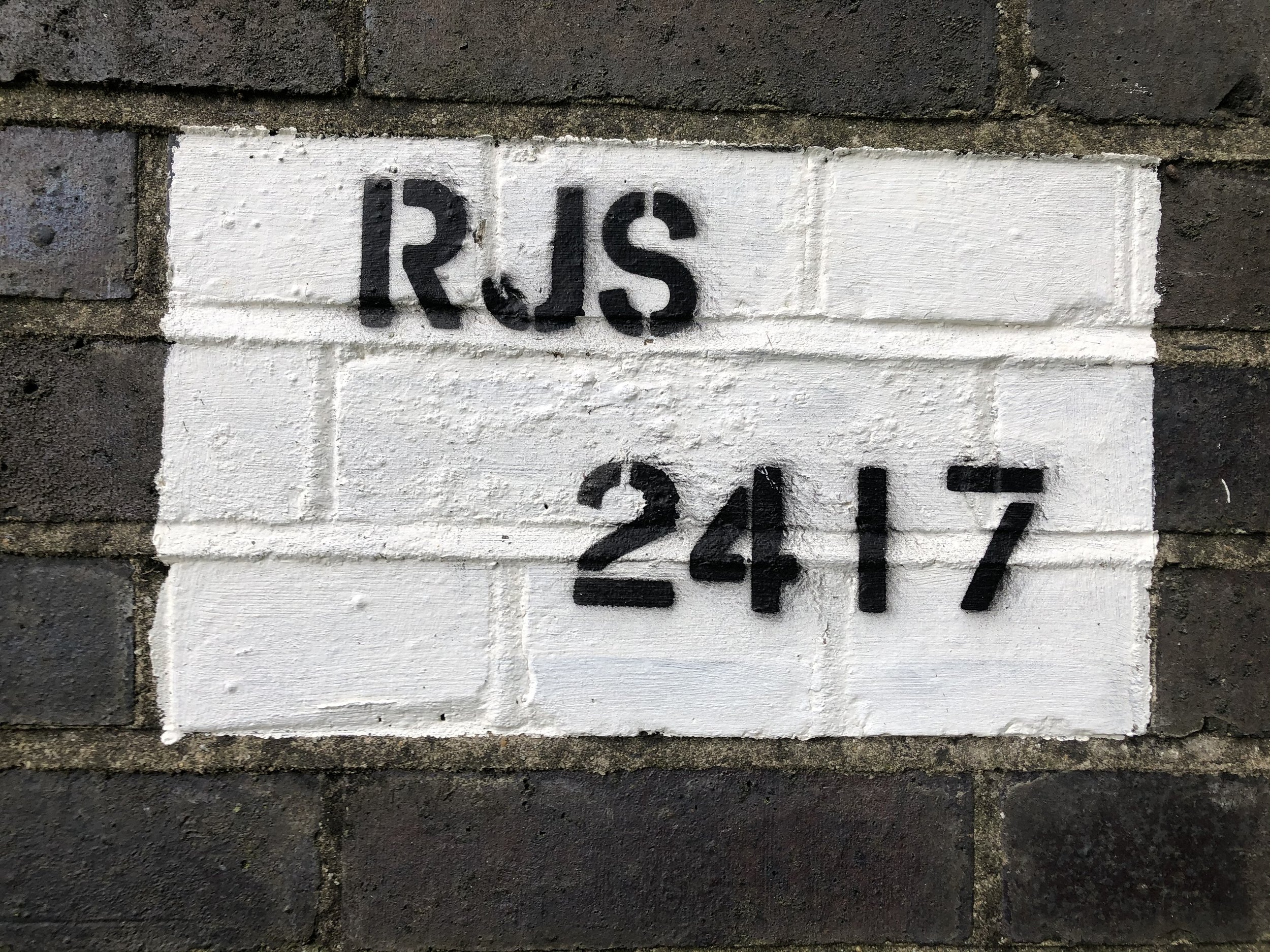
RJS 2417 bridge
Located at Sporle road Swaffham two butresses remain from the Swaffham Roudham Junction line
RJS stands for Roudham Junction Swaffham.


Leaving Swaffham for Dunham
The railway line passed under a small bridge located at Procession Lane and then passed under another bridge at Sporle Road. Based on Google Street View, the bridge identification number at Sporle Road appears to be MTD 2385. It's interesting to note that both of these bridges still exist today. After passing through these two bridges, the railway would have continued to the next station, where it would have crossed over a road called The Street. Regrettably, the railway bridge has been demolished, and there's no evidence of its existence. However, the railway track banks are overgrown and still remain as a reminder of what was once there.
Sporle Station
The next stop on the line was Sporle station, which was only temporary and short-lived. It served as a terminus for the line from Swaffham while construction works were being carried out towards Dereham. Information about Sporle station is scarce, and there are no known photographs of it. The station opened in 1847, but sources vary on the date of its closure, with some stating that it closed in 1850. Therefore, it is uncertain when it actually closed. However, there is currently no evidence to support the claim that a temporary station ever existed in Sporle. According to Google Maps, there is a farm called Railway Farm located approximately where the station used to be many years ago.
"This is the approximate location where the temporary station at Spole would have been situated."
Thanks to Google Maps.
The location of Sporle station cannot be found on any historic maps.

Thanks to the National Library of Scotland for the maps used
Heading off towards Dunham
Track bed inbetween Swaffham and Dunham.

Drone footage captured the track leading to Swaffham from a bridge near Dunham station.


Many years ago, the railway passed through a cutting after Sporle station on its way to Dunham. Passing underneath this bridge.


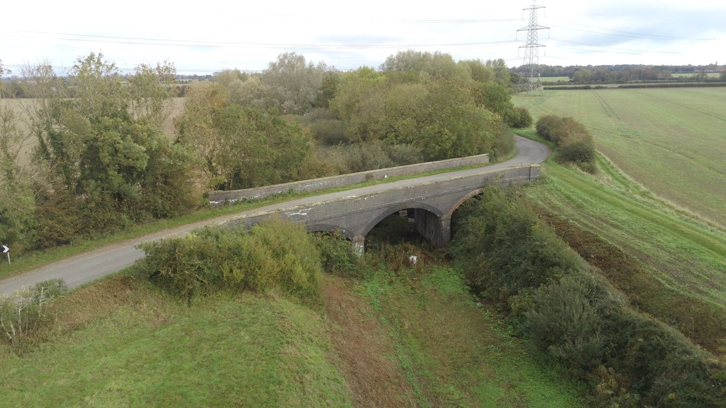


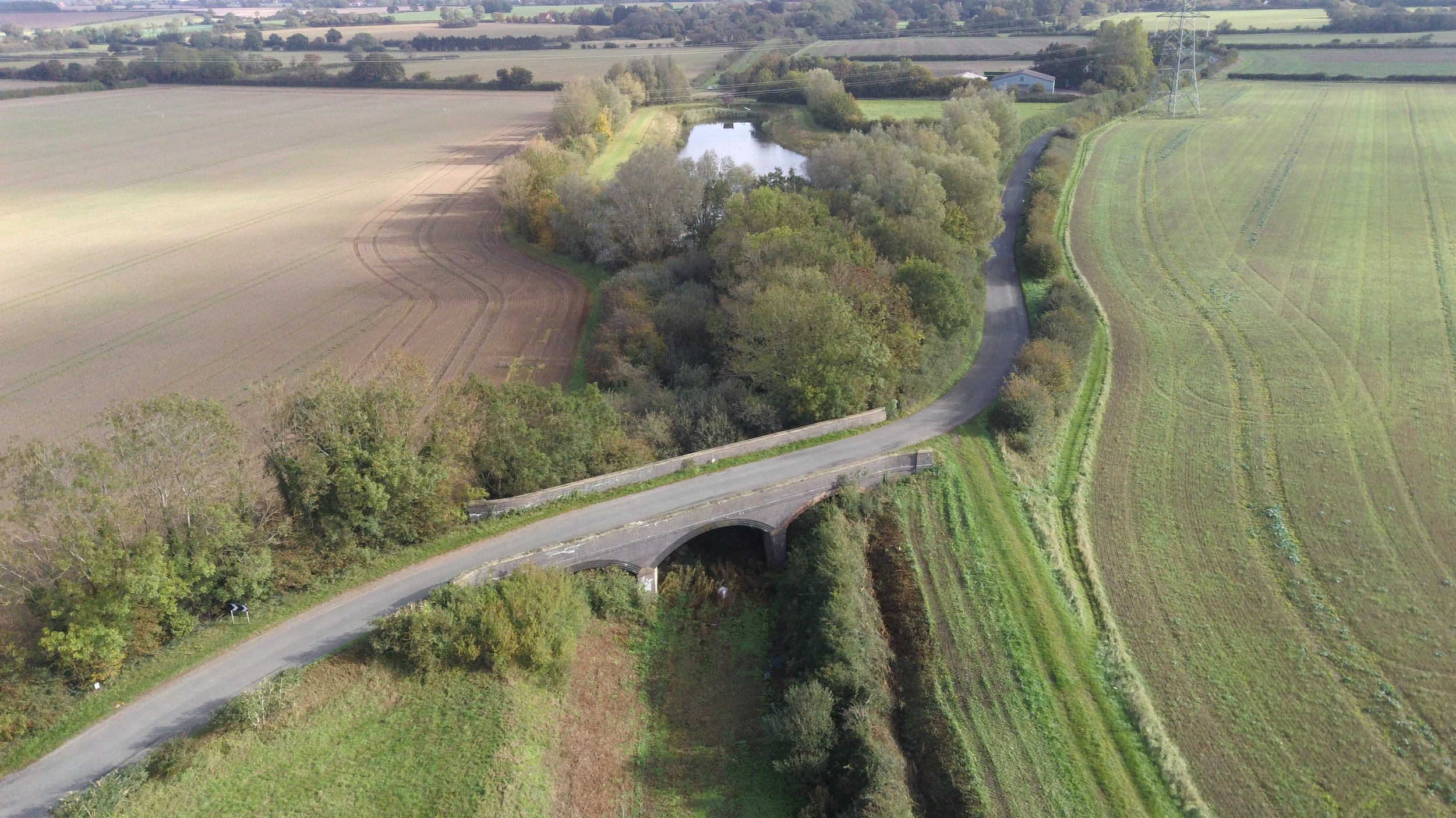
After crossing the bridge, the railway continued on towards Dunham Station. On its way, the railway would have also gone over Palgrave Road before reaching Dunham. Nowadays, a lake has been built over the track bed after the bridge, and the Palgrave Road bridge is no longer there.
All that remains is a part of the elevated track bed.
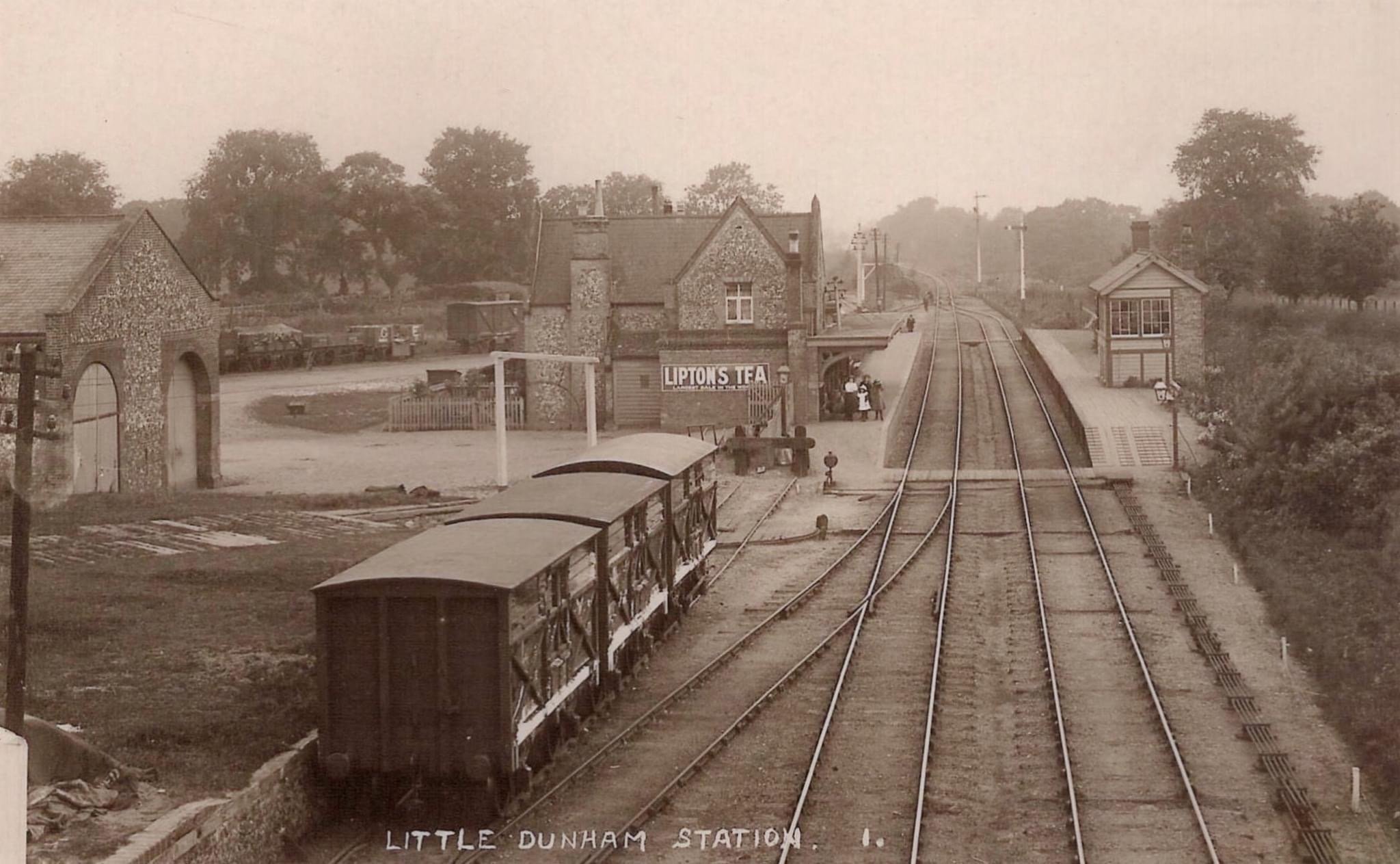
Dunham station
Dunham Station was established in 1848 and served as a railway station until 1968. It is located 18 miles away from King's Lynn and features two platforms with a passing loop. The station also had a freight shed located perpendicular to the main line, which was accessible via a turntable. However, based on Ordnance Survey maps, the turntable has been removed, and the sidings were extended by the early 1900s. On the downside of the platform stood a brick-built signal box.
Presently, Dunham station serves as a private residence.
Please find attached the historic maps of Dunham Station which clearly depict the position of the station

Dunham's Ordnance Survey maps from the early 1900s show cattle sheds and a possible turntable, courtesy of the National Library of Scotland.

The map from 1937-1961 only shows Dunham's railway sidings and passing loop, with no turntable present, courtesy of the National Library of Scotland.
Google Maps position of Dunham station
Little Dunham Station
year unknown and photographer unknown
In 2020, the only visible part of Dunham station that I could capture in my photograph was this small part of the platforms.

Upon leaving Dunham station, the train travelled under a bridge and into a Cutting and through the picturesque Norfolk Countryside to its next destination, Fransham.
Only 1mile 23 chains away
Please join us on this journey and click the link below for part five along the Lynn Dereham Line.